Hello friends! The following is the discovery of Mount Sinai, The Rock of Horeb and the pagan altar where the Children Of Israel built a golden calf.
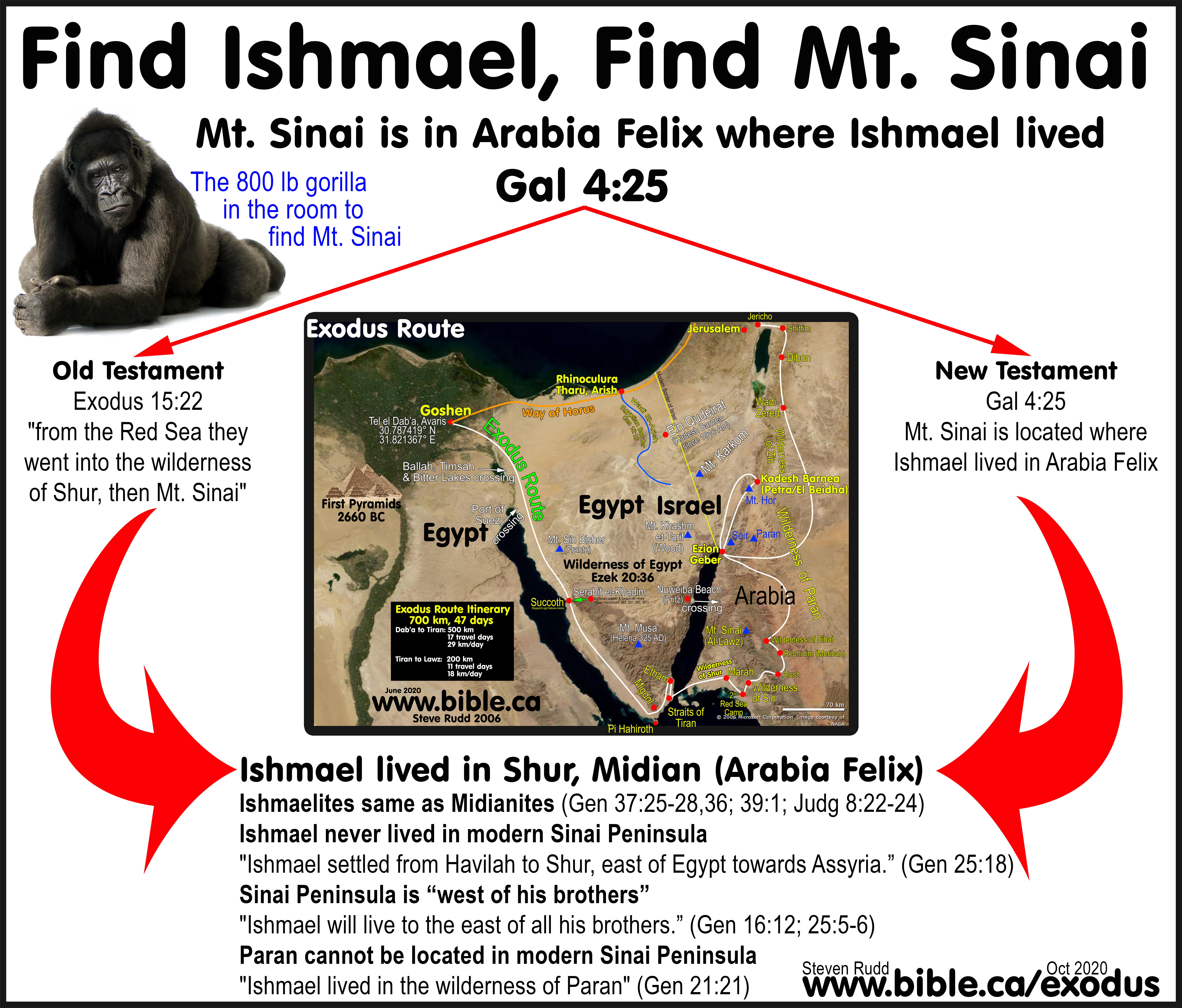
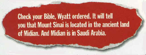
It has been bashed as not being the real Mount Sinai because it isn't located in Egypt. However, Apostle Paul said Mount Sinai is located in Arabia.
let me show you a picture i've taken from my Bible
It has been bashed as not being the real Mount Sinai because it isn't located in Egypt. However, Apostle Paul said Mount Sinai is located in Arabia.
Galatians 4:24-25
24 Which things are an allegory: for these are the two covenants; the one from the mount Sinai, which gendereth to bondage, which is Agar.
25 For this Agar is mount Sinai in Arabia, and answereth to Jerusalem which now is, and is in bondage with her children.
24 Which things are an allegory: for these are the two covenants; the one from the mount Sinai, which gendereth to bondage, which is Agar.
25 For this Agar is mount Sinai in Arabia, and answereth to Jerusalem which now is, and is in bondage with her children.
let me show you a picture i've taken from my Bible

Picture taken from my Bible

Picture taken from my Bible
Picture taken from http://www.bible.ca/archeology/bible-archeology-exodus-mt-sinai-arabia-gal-4-25.htm
(Please click the above for more detailed information)
Queen Helena, chose Jebel Musa in the Sinai Peninsula as the site of the Biblical Mount Sinai but this location is part of Egypt! (Research Constantine and Queen Helena)
The Chosen people of Israel left Egypt, which also means Ron Wyatt's discovery of the Red Sea Crossing area is correct!
The Chosen people of Israel left Egypt, which also means Ron Wyatt's discovery of the Red Sea Crossing area is correct!
The following is a very exciting find, and i assure you, you will not find a better Mount Sinai with a more convincing rock and a more likely altar for the golden calf, because this is The Real Mount Sinai! :D
I will post the following findings as well as a more in depth story of the findings right after this one (Credit given at the end of each article :D)
Exodus 19
19 In the third month, when the children of Israel were gone forth out of the land of Egypt, the same day came they into the wilderness of Sinai.
2 For they were departed from Rephidim, and were come to the desert of Sinai, and had pitched in the wilderness; and there Israel camped before the mount.
3 And Moses went up unto God, and the Lord called unto him out of the mountain, saying, Thus shalt thou say to the house of Jacob, and tell the children of Israel;
4 Ye have seen what I did unto the Egyptians, and how I bare you on eagles' wings, and brought you unto myself.
5 Now therefore, if ye will obey my voice indeed, and keep my covenant, then ye shall be a peculiar treasure unto me above all people: for all the earth is mine:
6 And ye shall be unto me a kingdom of priests, and an holy nation. These are the words which thou shalt speak unto the children of Israel.
7 And Moses came and called for the elders of the people, and laid before their faces all these words which the Lord commanded him.
8 And all the people answered together, and said, All that the Lord hath spoken we will do. And Moses returned the words of the people unto the Lord.
9 And the Lord said unto Moses, Lo, I come unto thee in a thick cloud, that the people may hear when I speak with thee, and believe thee for ever. And Moses told the words of the people unto the Lord.
10 And the Lord said unto Moses, Go unto the people, and sanctify them to day and to morrow, and let them wash their clothes,
11 And be ready against the third day: for the third day the Lord will come down in the sight of all the people upon mount Sinai.
12 And thou shalt set bounds unto the people round about, saying, Take heed to yourselves, that ye go not up into the mount, or touch the border of it: whosoever toucheth the mount shall be surely put to death:
13 There shall not an hand touch it, but he shall surely be stoned, or shot through; whether it be beast or man, it shall not live: when the trumpet soundeth long, they shall come up to the mount.
14 And Moses went down from the mount unto the people, and sanctified the people; and they washed their clothes.
15 And he said unto the people, Be ready against the third day: come not at your wives.
16 And it came to pass on the third day in the morning, that there were thunders and lightnings, and a thick cloud upon the mount, and the voice of the trumpet exceeding loud; so that all the people that was in the camp trembled.
17 And Moses brought forth the people out of the camp to meet with God; and they stood at the nether part of the mount.
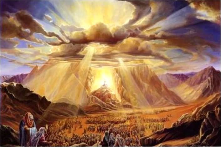
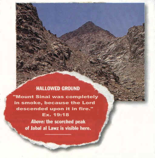
18 And mount Sinai was altogether on a smoke, because the Lord descended upon it in fire: and the smoke thereof ascended as the smoke of a furnace, and the whole mount quaked greatly.
19 And when the voice of the trumpet sounded long, and waxed louder and louder, Moses spake, and God answered him by a voice.
20 And the Lord came down upon mount Sinai, on the top of the mount: and theLord called Moses up to the top of the mount; and Moses went up.
21 And the Lord said unto Moses, Go down, charge the people, lest they break through unto the Lord to gaze, and many of them perish.
22 And let the priests also, which come near to the Lord, sanctify themselves, lest the Lord break forth upon them.
23 And Moses said unto the Lord, The people cannot come up to mount Sinai: for thou chargedst us, saying, Set bounds about the mount, and sanctify it.
24 And the Lord said unto him, Away, get thee down, and thou shalt come up, thou, and Aaron with thee: but let not the priests and the people break through to come up unto the Lord, lest he break forth upon them.
25 So Moses went down unto the people, and spake unto them.
Praise The Lord JESUS CHRIST!!!
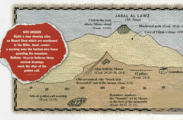
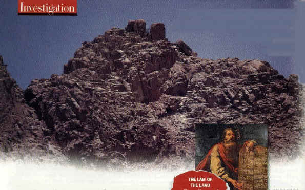
The Blackened Peak of the REAL Mount Sinai
found by Ron Wyatt
The Blackened Peak of the REAL Mount Sinai
found by Ron Wyatt
Above: Watch 17 minute segment on Mt. Sinai from our DVD
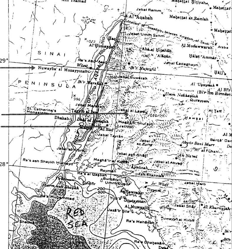
The traditional location of Mt. Sinai in the Sinai Peninsula is based upon tradition that was started by Constantine or his mother, both of whom claimed to have dreams of where biblical sites were located.
"There is no Jewish tradition of the geographical location of Mt. Sinai; it seems that its exact location was obscure already in the time of the monarchy....The Christian hermits and monks, mostly from Egypt, who settled in Southern Sinai from the second century C.E. on, made repeated efforts to identify the locality of the Exodus with actual places to which the believers could make their way as pilgrims. The identification of Mt. Sinai either with Jebel Sirbal near the oasis of Firan (Paran; Nilus, Cosmos Indicopleustes), or with Jebel Musa, can be traced back as far as the fourth century C.E. [TO CONSTANTINE'S TIME]." Jewish Encyclopedia, Vol. 14, p. 1599
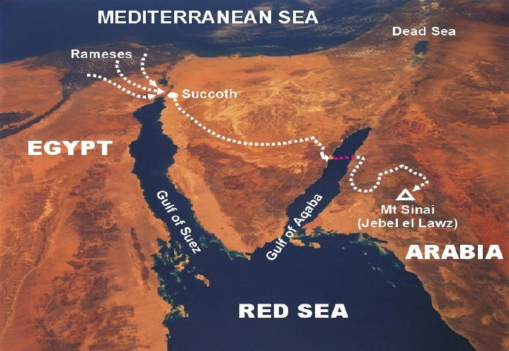
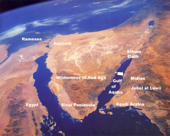
Above: The actual route of the exodus from Egypt as discovered by Ron Wyatt
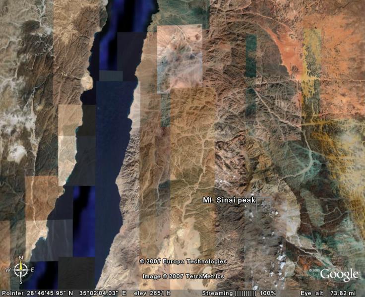
Since Ron Wyatt found the Red Sea crossing, we know Mt. Sinai
must be EAST of the Gulf of Aqaba
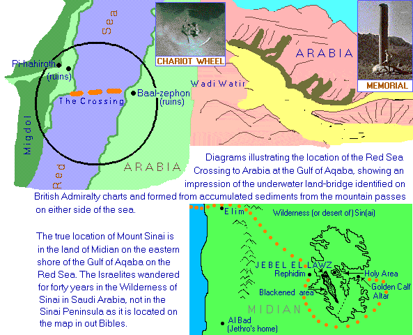
"This location of Midian EAST of the Gulf of Aqaba is verified by many other scholars. "The Biblical references connecting SINAI with Mount Seir, Edom and the LAND OF MIDIAN seem clearly to indicate this region EAST OF THE AELANITIC GULF (g. of AKABA) as pointed out by Beke (1834), Wallhausen (1886), Sayce (1894), Moore (1895), Shede (1897), Gall (1898), Gunkel (1903), Edward Meyer (1906), Schmidt (1908), Gressmann (1913), Haupt (1914) and by Alois Musil in 'The Northern Hegaz' (1911)" (On the Track of the Exodus, p. 87).
Bible Texts Locate the Real Mount Sinai
Mt. Sinai has to be in Midian:
- "Moses fled from the face of Pharaoh and dwelt in the land of Midian; and he sat down by a well" Ex. 2:15 NKJV. Maps indicate Midian is east of the Gulf of Aqaba in Northwest Saudi Arabia, in the area shown on the map above.
Moses fled to a foreign land, not to the Sinai peninsula:
- "And she [Zipporah] bore him a son, and he called his name Gershom; for he said, "I have been a stranger in a foreign land" Ex. 2:22. Moses was in a different country, away from any Egyptians in Saudi Arabia. He could not have been in the Sinai Peninsula, as that area was Egyptian controlled territory, full of Egyptian mines and communication towers. Moses would have been easily captured in that area.
Midian and Horeb are in the same location:
"Now Moses kept the flock of Jethro his father-in-law, the priest of Midian. And he led the flock to the back of the desert, and came to Horeb, the mountain of God" Ex. 3:1. Jethro lived in the vicinity of Mount Sinai. Jethro was the leader of the Midianites who were found in this area, "East of the Gulf of Aqaba in the northwestern regions of the Arabian Desert" Britanica.
When researching the location of Mt. Sinai in Saudi Arabia that Mr. Wyatt proposed, I went to the East Tennessee State University Library and found two extremely detailed maps of Saudi Arabia. On BOTH maps I found the name "Jethro" next to the town of Al Bad, which is near Jebel el Lawz, the correct Mt. Sinai! See maps below. Jethro was Moses' father-in-law as we saw in the texts above. He was from the town of Al Bad, according to the local people who live there today, which is only about 15 miles from Jebel el Lawz. The local people there today told Ron Wyatt that Jethro was from that area.
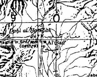
Above: Magha'Ir Shuayb means the caves of Jethro.
Second map (Click to enlarge)
Second map (Click to enlarge)
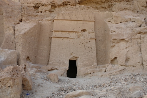
Above: One of the caves of Jethro or Moses' cave near Al Bad
Above: Dr. Kim standing in the entrance to the cave.
- "So He [God] said, 'I will certainly be with you. And this shall be a sign to you that I have sent you: When you have brought the people out of Egypt, you shall serve God on this mountain'" Exodus 3:12. Moses was to bring the children of Israel from Egypt to this same mountain in Midian, near Jethro's home, in a foreign land.
- "For this Hagar is Mount Sinai in Arabia" Galatians 4:25. Here we are clearly told where the mountain should be located, in Arabia. But where is Arabia? "...It is bordered on the W by the Gulf of Aqaba and the Red Sea" Britanica. This clearly rules out the Sinai Peninsula, but it does include Saudi Arabia of course.
- "Then, at this saying, Moses fled and became a sojourner in the land of Midian, where he had two sons. And when forty years had passed, an Angel of the Lord appeared to him in a flame of fire in a bush, in the wilderness of Mount Sinai." Acts 7:29,30. All historically accurate maps, such as some produced by secular companies like National Geographic (see map at top of page), show Midian in Saudi Arabia. Unfortunately, maps placed in Bibles by the publishers may have Midian in the Sinai Peninsula in order to fit tradition, but not the Bible or the historical record.

Above: On the way to Mt. Sinai, Moses was in Elim in Saudi Arabia in the
Midian Region, with 12 wells, as mentioned in the Bible. On the pathway to Mt. Sinai in Arabia.
Midian Region, with 12 wells, as mentioned in the Bible. On the pathway to Mt. Sinai in Arabia.
The Rock which Flowed Forth Water

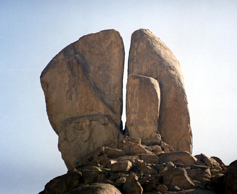
Above - Giant split rock which God provided for the Children of Israel.
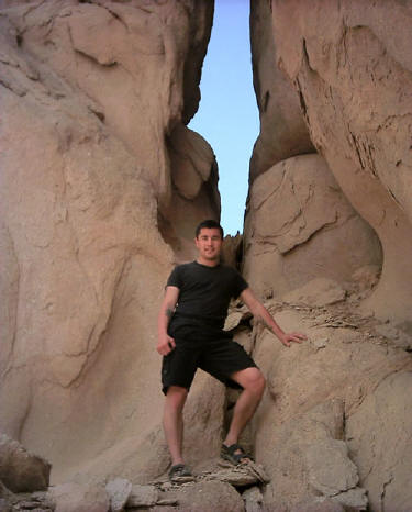
Above - Aaron Sen stands in the split of this giant rock. Notice the obvious signs of erosion,
in this desert region. www.wyattarchaeology.com
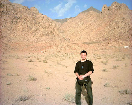
Josephus Said It Was the Highest Mountain
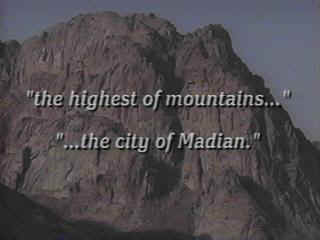
Mount Sinai in Arabia
Encampment is to the right of peak.
Others have come along claiming to have found this mountain, but Ron Wyatt was the first. Mr. Wyatt first went out to the mountain in 1984, and he told David Fasold about the discovery, who then told two men, Cornuke and Williams, who claim they went out in 1988, to see the mountain, but there is no documented proof they actually ever were in Saudi Arabia.
Above - Aaron Sen stands in the encampment area of Mt. Sinai with the blackened peak in the distance.www.wyattarchaeology.com
Layout of Mountain & Artifacts
Documentary coming out soon on this discovery and the Red Sea Crossing!
Multi-million dollar production by Mahoney Media:
www.PatternsOfEvidence.com
View their video library!
Currently being shown in film festivals across the USA in 2014
www.PatternsOfEvidence.com
View their video library!
Currently being shown in film festivals across the USA in 2014
Tree Between Two Boulders
Above: Top portion of photo shows a solitary tree between two boulders.
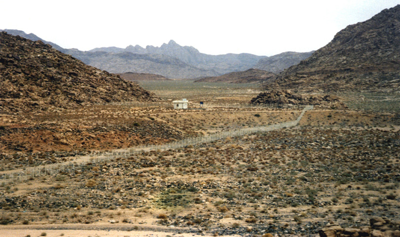
Above: Guard house, government sign, and fence around the front of Jebel el Lawz
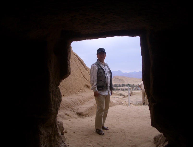
The Altar of the Golden Calf
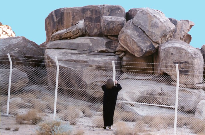
Above: The base of which the golden calf altar was placed atop. Notice inscriptions of bulls.
This is located in the encampment area at Mt. Sinai in Arabia and in Midian.
This is located in the encampment area at Mt. Sinai in Arabia and in Midian.
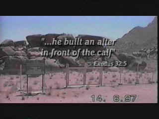
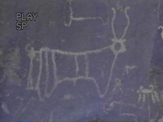
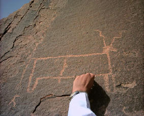
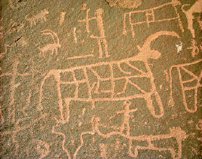
Above left - A dozen giant boulders are stacked in the encampment area and reveal 12 ancient Egyptian petroglyphs of bulls. It is believed the golden calf was placed upon these rocks. Large altars are found on the east and west sides of the mountain. (two lower photos courtesy Aaron Sen).
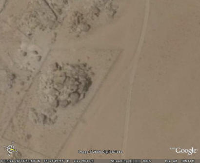
Above: Using Google Earth you can see the fence around these large rocks, out in the encampment area.
Rocks: 28 34' 52.78" N 35 23' 46.06" E
Guard house & fence: 28 35' 12.50" N 35 23' 08.36" E
Rocks: 28 34' 52.78" N 35 23' 46.06" E
Guard house & fence: 28 35' 12.50" N 35 23' 08.36" E
Government Acknowledges Archaeological Significance
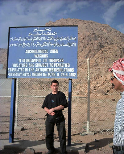
Above - Aaron Sen stands next to government sign at base of Mt. Sinai acknowledging this archaeological area. Photo Aaron Sen www.wyattarchaeology.com
After Mr Wyatt found this site in 1984, and visited it again a year later, the Saudi government erected a fence and a guard house preventing access to the Holy Precinct area at the foot of the mountain on the eastern side. The sign above states, "Archaeological area...unlawful to trespass, subject to penalty." When Ron and his two sons made their fist trip into Saudi Arabia, they were accused of being spies and were held prisoner for two months, awaiting execution. After Ron helped to heal many sick prisoners, the authorities listened to his story and accompanied him to the column at the Saudi beach, then to Mt. Sinai. It was then they believed him, but they had to confiscate his photographs before letting him go.
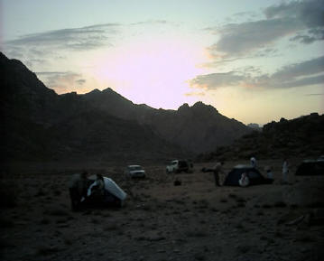
Aaron Sen and Mahoney Media camp overnight in the same spot where
Moses and the Children of Israel lived for a year at Mt. Sinai. www.wyattarchaeology.com
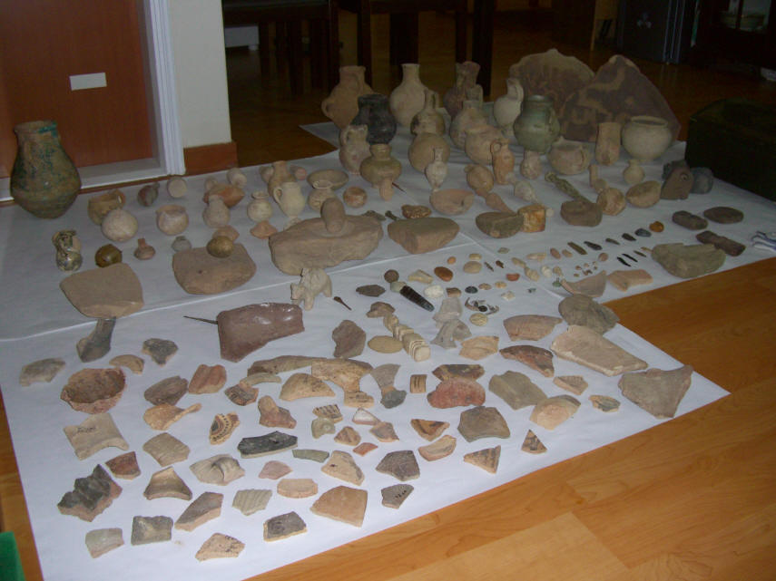
Above: The amazing collection of artifacts found by Dr. Kim from his 12 trips out to Jebel el Lawz.
Above: Dr. Kim next to drawings in the encampment area. Dr. Kim was a personal physician
to the prince in Saudi Arabia and to the king. He lived in Saudi around 15 years.
to the prince in Saudi Arabia and to the king. He lived in Saudi around 15 years.
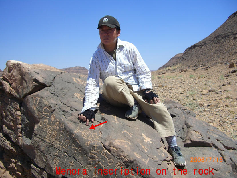
Above: In the encampment area, Dr. Kim pointing to the oldest image of the golden oil lamp stand ever found.
This was where the lamp stand was first made.
This was where the lamp stand was first made.
Hershel Shanks, editor of Biblical Archaeology Review was quoted in Newsweek that "Jebel el Lawz is the most likely site for Mount Sinai."


Ron was on CBS News on April 17, 1984, telling about his trip to see the mountain and what he found there. He had entered the country without a visa and was thought to be a spy. He and is sons spent 76 days in prison and could have been executed, but God delivered them. Ron made these comments on air: "We found some chariot parts that looked like the chariots found in King Tut's tomb in the Gulf of Aqaba, WEST OF THIS JABEL EL LAWZ. Now, we found these at depths from 60 feet out to 200 feet and over a stretch of about a mile and a half. And we believe that was the crossing site, so in the Biblical narrative, they arrived at Mt. Sinai after crossing the Red Sea. The language in the Bible indicated that they stayed 'IN' A MOUNTAIN; ENCLOSED IN A MOUNTAIN. So, an aerial map showed that this JABEL EL LAWZ HAD A LARGE VALLEY ENCLOSED IN THE RIM OF AN ANCIENT VOLCANO. There's about 5,000 acres in there. We felt this was the place. And, in Exodus 24:4 and Leviticus 6:28, 11:33 and 15:12, it tells of SOME ARTIFACTS that were to be found. There would be TWELVE PILLARS OF STONE AND AN ALTAR AND SOME POTTERY, and so this is why we looked at that particular mountain."
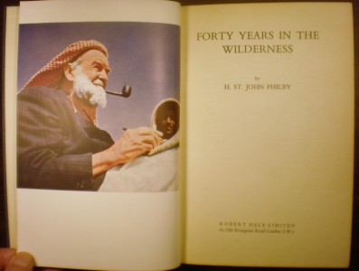
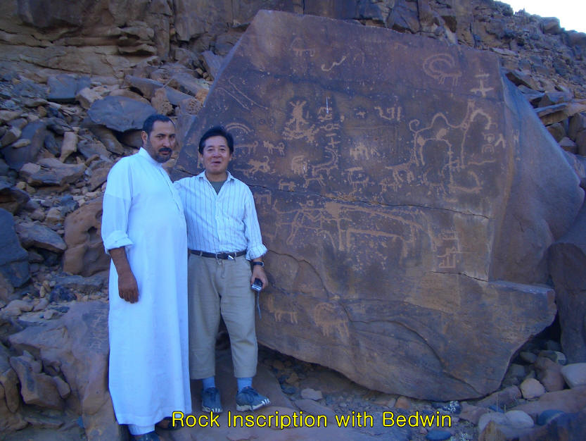
The British author and archaeologist H. St. John Philby spent a significant portion of his life exploring the wadis and mountains of northwest Arabia -- the biblical land of Midian. In the book he wrote following his exploration of Midian, Philby outlines his adventures in the mountainous land:
"From here my guide and I climbed up the cliff to visit THE 'CIRCLES' OF JETHRO on the summit of Musalla ridge, from which we climbed down quite easily to our camp on the far side. [Alois] Musil tells us that he had to fetch a circuit of two kilometres to approach the ridge from the north; but the more direct approach presented no difficulty. A cairn marked the spot where JETHRO IS SUPPOSED TO HAVE PRAYED, and all round it are numerous circles, the significance of which is difficult to guess: presumably some stance marked out for the benefit of pilgrims visiting the scene of Jethro's argument with the Midianites. from here I had a magnificent view of the WHOLE OF THE MIDIAN MOUNTAIN RANGE: with LAUZ and its sister peaks in the northeast and Maqla' a very little north of east, with the valley of al-Numair separating the latter from the long low RIDGE OF ALL MARRA, extending from east to south-east, where the TWO PEAKS OF HURAB stood out in front of the great range of Zuhd, which runs down to a point not far from the sea to our southward...the spot that held my imagination was the smooth, double-headed, granite boss of HURAB (pronounced HRUB by 'Id), AN OBVIOUS CANDIDATE FOR IDENTIFICATION WITH THE MOUNT HOREB OF THE EXODUS, with the burning bush and the tablets of the Law: THE ONLY CANDIDATE FOR THE HONOUR WHICH CAN CLAIM TO HAVE PRESERVED THE NAME.
"So far as I am aware the existence of THIS HILL IN MIDIAN HAD NEVER BEEN NOTED BEFORE; and naturally I was anxious to explore it and its surroundings....A couple of miles brought us to the edge of a wide chasm, with forty-foot cliffs of sandstone and silt along the left bank, and an easier rise on our side, strewn liberally with large granite and basalt boulders from the steep flank of HURAB just ahead of us. The Land-Rover could go no farther, and I made my inspection of the valley and the edge of the mountain on foot. The massif is granite, with dykes of basalt at intervals, running from south-west to north-east at an angle of thirty degrees. I did not attempt to emulate Moses' feat of climbing it, if indeed he did; but I made a careful search in the valley and its sandstone cliffs in the hope of finding a few Badawin wasms, but the channel itself, 100 yards wide and thickly covered with acacia bushes and trees, and the deep gorge of the mountain from which it emerges, were quite impressive....According to Hasballah, the name of Hurab applies primarily to the wadi, while he called the mountain itself Al Manifa (which simply means 'the lofty')." -- Forty Years in the Wilderness. Ernest Benn Ltd., London. 1957, pp. 222-224.
Philby never saw the blackened peak of Jebel el Lawz from what we can tell it was snow covered at the time. So others in the past knew about this mountain but the evidence was never brought out for the world to see.
Some Television Coverage....
Dateline NBC has featured Jebel el Lawz in its program
and this has aired multiple times.
The 700 Club has featured Jebel el Lawz also.
Source: http://www.arkdiscovery.com/mt__sinai_found.htm
Here's the information regarding the maps :)
The True Location of the Red Sea Crossing
and this has aired multiple times.
The 700 Club has featured Jebel el Lawz also.
Source: http://www.arkdiscovery.com/mt__sinai_found.htm
Here's the information regarding the maps :)
The True Location of the Red Sea Crossing
Exodus 13:17-22, "And it came to pass, when Pharaoh had let the people go that God didn't lead them by the land of the Philistines, although it was the more direct route to Canaan; for He said, 'In case the people become discouraged when they have to fight, and they return to Egypt'. So He led the them by way of the wilderness of the Red Sea: and the children of Israel went out of the land of Egypt in ranks.
Moses took the bones of Joseph with him for Joseph had charged the children of Israel, saying, 'God will be with you; and you shall carry my bones away hence with you'. And they took their journey from Succoth, and encamped in Etham, on the edge of the desert.
And the Lord went before them by day in a pillar of a cloud, to lead the way; and by night in a pillar of fire, to give them light; so they might travel by day and night: He took not away the pillar of the cloud by day, nor the pillar of fire by night, from before the people".
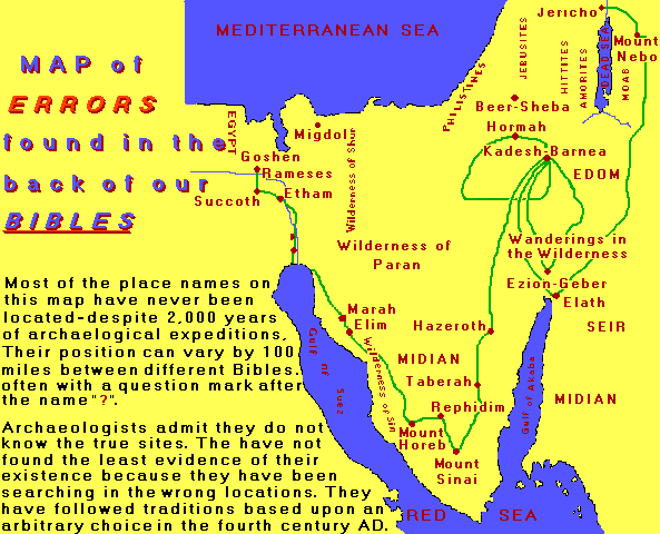
Now I want you to compare the Bible text with the maps in the back of our Bibles. The map does not match God's Word. I've prepared my maps based on Bible text. You'll notice there were two highways that led from Egypt to the Promised Land. The shorter northern route, or "way of the Land of the Philistines", followed the Mediterranean Coast. The southern route, or "way of the wilderness by the Red Sea", described a huge loop through the Peninsula bound by the Red Sea and is about twice the distance.

They gathered to Succoth from their homes and farms in the land of Raameses which is the land of Goshen. Succoth was a military base on the eastern border of Egypt large enough for this great number of people and flocks to assemble in ranks to depart from Egypt in an orderly fashion by the way of the wilderness toward the Red Sea (Exodus 13:18).
Succoth was called variously "Tharu", T'aru", and "Takut."
Here is a quote from "Life in Ancient Egypt" by Adolf Erman (28, 537): "The isthmus of Suez was of the greatest consequence also from a military point of view - it was doubtless fortified in very early times. Probably here stood the great fortress of T'aru, often spoken of as the starting-point for the expeditions into Syria,.."
"The line of fortifications which was intended to keep back these Bedouins of the Delta, is met with as early as the Middle Empire, and is still standing. It consists of a wall strengthened by small towers... this formed an obstruction which the slaves who tried to escape from Egypt, and Bedouins who wanted to pasture their cattle on the fields of the Delta, found difficult to pass.
At this time we also meet with a defensive work of another kind, namely a broad canal, which presumably connected the lakes of the isthmus together. At the point where a bridge crossed this canal were strong fortresses on both sides... The great fortress which defended this bridge was the fortress of T'aru', which is so often mentioned as the starting point of the military expeditions."
In ancient Egypt, there was a line of guarded fortifications along the canal which connected the Gulf of Suez with the Mediterranean Sea. Satellite and infrared photos show the path of this ancient canal. At the point where one would leave Egypt proper and go into the Sinai desert, there was the fortress and a bridge of Tharu.
Here the Egyptian army assembled in preparation for their military expeditions to the north. Armies consisted of a immense numbers of men, horses and chariots which required a large area to assemble.
Here Moses organized Israel for their journey.
On Nisan 14, at about 3:00 in the afternoon they had killed the first Passover lamb, and celebrated the feast in haste their homes in Goshen, with their loins girt, standing with their shoes on their feet and their staff in their hand, ready for the first exodus. The Passover meal commenced the first of seven days of the feast of Unleavened Bread. Their day was reckoned from evening to evening. So before sundown on Nisan 15, they had departed from Rameses and assembled in Succoth which was OUT of Egypt proper, as the Lord had promised.
Exodus 12:17, 42, "You shall observe the feast of unleavened bread; for in this selfsame day have I brought your armies out of the land of Egypt: therefore shall you observe this day in your generations by an ordinance for ever. . . It is a night to be much observed unto the Lord for bringing them out from the land of Egypt: this is that night of the Lord to be observed of all the children of Israel in their generations" (also Exodus 13:3).
Nisan 16, which commenced after sundown on Nisan 15, was the start of the feast of Pentecost when Israel commenced their journey over the caravan route across the desert to Etham.
Exodus 13:18, "And the children of Israel went up harnessed out of the land of Egypt." Anywhere east of Succoth was "outside the land of Egypt" -- so Israel was out of Egypt beforethey arrived at the Red Sea.
Exodus 13:20, "They took their journey from Succoth, and encamped in Etham, on the edge of the desert". In other words, this highway led from Succoth through the "Wilderness of the Red Sea" along the caravan route through the mountainous land to Etham, the land that encircled the northern end of the Gulf of Aqaba - " in the edge of the wilderness", or desert. We know Etham was not a town, because Israel were in Etham before they crossed the Red Sea and they were still in Etham on the eastern shore.
Numbers 33:8, "And they departed from before Pi-hahiroth and passed through the midst of the sea into the wilderness, and went three days' journey in the wilderness of Etham, and pitched in Marah."
That's according to the text. However the Bible map disagrees with the text, as it incorrectly shows Israel still in Egypt before the Red Sea crossing. Because of preconceived ideas, and because Egypt borders the western shore of the Gulf of Suez, theologians drew the crossing at the head of the Gulf. However, our Bible text says the Hebrews were out of the land of Egypt before they crossed the wilderness of the Peninsula, and that they turned off the highway crossing the desert, to travel to the Red Sea coast (Exodus 14:1). Clearly, Israel found the Sea not at the Gulf of Suez, but at the Gulf of Aqaba, on the western coast of the Sinai Peninsula (Exodus 14:1-2).
Concerning the route by which Moses led the children out of Egypt, Josephus writes, "That land was difficult to be traveled over, not only by armies, but by single persons. Now Moses led the Hebrews this way, that in case the Egyptians should repent and be desirous to pursue after them, they might undergo the punishment of their wickedness, and of the breach of those promises they had made to them.
As also he led them this way on account of the Philistines, who had quarreled with them, and hated them of old, that by all means they might not know of their departure, for their country is near to that of Egypt; and thence it was that Moses led them not along the road that tended to the land of the Philistines, but he was desirous that they should go through the desert, that so after a long journey, and after many afflictions, they might enter upon the land of Canaan. Another reason of this was, that God commanded him to bring the people to Mount Sinai, that there they might offer him sacrifices (Exodus 3:12)". Josephus also has the Israelites traveling by the southern road through the wilderness bound by the two gulfs of the Red Sea. When the road turned north toward Canaan, God told Moses to turn south into the road that led to Pi-hahiroth on the coast of the Gulf of Aqaba, opposite Baal-zephon in Arabia,not Suez in Egypt.
Baal means "Lord", and was the title of the supreme god of the Canaanites. Baal-zephon means "Lord of the North", a north-west Semitic "sea" or "storm" god. It seems unlikely this town would be inland in Egypt, where many theologians chose to locate it.
Theologians haven't found these cities because they have searched on the wrong coast. They plot them at locations varying hundreds of miles from map to map, placing a question mark by the city.
Exodus 14:1-4, "And the Lord spoke unto Moses, saying, 'Speak unto the children of Israel, that they turn and camp before Pi-hahiroth between Migdol and the sea, you shall encamp by the sea opposite Baal-zephon. For Pharaoh will say of the children of Israel, "They are entangled in the mountains, the wilderness has shut them in". And I will harden Pharaoh's heart, that he shall follow after them; and I will be honoured upon Pharaoh, and upon all his host; that the Egyptians may know that I am the Lord'. And they did so."
When God gave Moses these instructions it's evident that Moses was familiar with this territory.
Leaving the highway, the Hebrews traveled along the Wadi Watir, a natural road through the wide mountain gorge. The Israelites would have been traveling for close to one week because the journey from Succoth to the real Pi-hahiroth on the western coast of the Gulf of Aqaba was about 200 miles. Retreat was impossible. And together with their flocks and herds they were encompassed by the mountains and cut-off ahead by the sea.
Despite descriptions by some starry-eyed authors, the topography of areas identified with Pi-harhiroth, Migdol, and Baal-zephon on our Bible maps does not match the geography of Moses' account. A glance at the topographical map shows a continuous coastal plain, 200 to 500 feet above sea level, with sandy beaches extending down the western shore of the Gulf of Suez as far as Ethiopia.
Let's read a little more of Josephus, "Now when the Egyptians had overtaken the Hebrews, they prepared to fight them, and by their multitude they drove them into a narrow place; for the number that pursued after them was six hundred chariots, with fifty thousand horsemen, and two hundred thousand footmen, all armed. They also seized on the passages by which they imagined the Hebrews might fly, shutting them up between inaccessible precipices and the sea; for there was on each side mountains that terminated at the sea, which were impassable by reason of their roughness, and obstructed their flight; wherefore they there pressed upon the Hebrews with their army, where the ridges of the mountains were closed with the sea; which army they placed at the gaps of the mountains, that so they might deprive them of any passage into the plain".
Later, as we'll calculate from the Bible text, Israel had traveled about six-days before crossing the Read Sea. Had they traveled for one week down the Gulf of Suez before crossing the Red Sea, Israel would be near to Ethiopia by the time the armies of Pharaoh caught them, and far from "the way of the wilderness of the Red Sea". But the Bible says they left Egypt before the Red Sea crossing. When they found themselves trapped at the Red Sea, Israel complained to Moses: Why have you brought us out of Egypt?
Exodus 14:10-12, "Is it because there were no graves in Egypt that you've taken us away to die in the desert?
Didn't we tell you in Egypt, "Let us alone, that we may serve the Egyptians?" For it would have been better to serve the Egyptians, than to die in the wilderness'."
According to the Bible maps, the children of Israel were still in Egypt, trapped by non-existent mountains at the head of the Gulf of Suez. But Israel didn't march around Egypt for a week to save Pharaoh's army a long chase across the desert in the event Pharaoh changed his mind. They were not IN Egypt. They traveled day and night to put as much distance between them as possible. They were not trapped at the Gulf of Suez in Egypt, but at the Gulf of Aqaba outside Egypt.
Now I want to mention Mount Sinai. When Moses fled from Egypt, he dwelt in the land of Midian. There he married Zipporah, one of the seven daughters of Reuel or Jethro who were descendants of Abraham and Keturah. And Moses worked as a shepherd for his father-in-law, Jethro, who was the priest and leader of Midian. He knew that land like the back of his hand. He knew where to find good pastures and water. And he knew how to get there from Egypt in a hurry. Moses was taking the Israelites to Midian by the shortest possible route - through the Red Sea. He wasn't marching around in circles at the Gulf of Suez. Moses had an appointment to meet God on Mount Horeb, in Midian.
Let's read Moses' Commission from God in Exodus 3:1-2. "Moses kept the flock of Jethro his father in law the priest of Midian: and he led the flock to the back of the desert, and came to the mountain of God, even to Horeb. And the angel of the Lord appeared to him in a flame of fire out of the midst of a bush: and he looked, and, behold, the bush burned with fire, and the bush was not consumed".
Where was Moses? He was in the land of Midian which is by the Gulf of Aqaba in Arabia. He was standing on Mount Horeb, which is Mount Sinai, with a flock of sheep on the backside of the desert. Mount Sinai is not in the Sinai Peninsula at all, but across the Red Sea in the land of Midian.
This is confirmed by the apostle Paul in Galatians 4:22-26, "It is written: Abraham had two sons, the one by a bondmaid, the other by a freewoman. He who was of the bondwoman was born after the flesh; but he of the freewoman was by promise. Which is an allegory: for these women type the two covenants; the one from the Mount Sinai, which genders to bondage, which is Agar.
For this Agar is Mount Sinai in Arabia, and types Jerusalem which now is, and is enslaved to the Law with her children. But Jerusalem which is above is free, which is the mother of us all".
Did you hear what Paul said? "This Agar is Mount Sinai in Arabia". If Exodus 3:1 and Galatians 4:25 place Mount Sinai in Arabia, it's probably still there. And the maps in our Bibles are wrong because they portray Mount Sinai in the Peninsula between the two gulfs.
It's like the godhead and other doctrines. The Bible says there is one God who is One Person. The denominations say, in a way there is one God, but He's three people. The Bible says we are to be baptized in the Name of the Lord Jesus Christ. The church baptizes into three of His many Titles.
There is a way that seems right to a man, but the end thereof is the way of death.
When Moses fled Egypt, he was in peril of his life. Pharaoh would have killed him (Exodus 2:15). We may be sure Moses didn't hang around in Pharaoh's backyard. And that's what the Sinai Peninsula was. According to the historian, James Montgomery, "the land west of the River of Egypt to the Gulf of Aqaba has always belonged to the Egyptian political sphere, and is the boundary of present-day Egypt" (Arabia and the Bible, 31).
Throughout the Sinai peninsula there is tremendous evidence of the ancient Egyptians having control of this area. Inscriptions tell of Egyptian mining operations; there are temples, as well as fortresses.
Had Moses led the people across the Gulf of Suez, they would have still been in Egyptian- controlled territory. But in Saudi Arabia, there is no evidence of Egyptian occupation.
Exodus 3:11-12, As he stood before the burning bush, "Moses said to God, 'Who am I, that I should go unto Pharaoh, and that I should bring forth the children of Israel out of Egypt?' And God said, 'Certainly I will be with you; this shall be a Token or miraculous evidence, that I have sent you: When you have brought forth the people outof Egypt, you shall serve God upon yjis mountain'. "
Moses knew the way of escape to a place of safety in a land across the sea where he had friends and was respected. Although his in- laws probably didn't expect him to come with two to three million of his relatives the way he did. The true location of Mount Sinai is "out of Egypt", and not in the Sinai Peninsula.
Exodus 13:21, "And the Lord went before them by day in a pillar of a cloud, to lead hem the way; and by night in a pillar of fire, to give them light; to travel by day and night".
Earlier I said that the Hebrews traveled for about one week before crossing the Red Sea. 600,000 men, plus women, children, and old folk would have numbered some two to three million. With them they carried their clothing, bedding, food, and shelter, leading their flocks and their herds, fowls and whatever else they had. We may imagine they left behind a trail of discarded goods, traveling day and night. No obstacle prevented their direct passage to meet God in the holy mountain.
Exodus 19:4, God said, "You've seen what I did unto the Egyptians, and how I bare you on eagles' wings, and brought you (swiftly) to Myself" (II Samuel 1:23).
In 1967, Moshe Dyan marched his troops from Nuweiba Beach crossing site to Suez City (near ancient Tharu/Succoth) in six days. Unlike Moses, who traveled both day and night, Moshe Dyan's troops camped at night.
The Israelites were told to eat only unleavened bread seven days - indicating they would be traveling constantly with no opportunity to bake bread.
Exodus 13:6, 8, "Seven days shall you eat unleavened bread, and in the seventh day, shall be a feast to the Lord. And you shall show your son in that day, saying, 'This is done because of that which the Lord did unto me when I came forth out of Egypt'."
We can estimate the duration of the journey to Pi-hahiroth if we calculate backwards from Exodus 19:16 and the giving of the Law on Mount Sinai. The Law was delivered on the day of Pentecost; that's 52-days after Israel had eaten the first Passover. It corresponds with the inauguration of the Church in the upper room, and to the coming translation of the Bride to the Wedding Supper of the Lamb in the Sky.
Working backwards to Exodus 19:1-2, we find that by the first day of Sivan, precisely forty-six days after their Passover in Egypt, Israel had reached the wilderness of the Sinai desert and camped before Mount Sinai. Not as it is portrayed on our Bible maps, but across the Red Sea in Arabia. On the fifteenth day of Iyyar, the second month after departing out of Egypt, Israel were thirty-days into their journey ready to break camp at Elim, near the coast of Midian (Exodus 16:1).
Retracing their steps after a time spent in Elim, we come to Marah where the water was bitter and could not be drunk until Moses cast in a particular tree "the Lord showed him", typing Jesus, the Tree of Life, and which healed the waters. From Marah we go back three days to the wilderness of Shur, on the Midian shore of the Red Sea by Baal-zephon where we can imagine Israel spent perhaps ten days, to the close of the feast of unleavened bread when they would have held "a feast unto the Lord" (Exodus 13:6) to sing God's praise in the defeat of Pharaoh's army. This would be their first chance to prepare a cooked meal, wash, pitch camp and rest, since the exodus from Succoth.
The Bible describes how Miriam the prophetess sang, and the women danced. There would have been great rejoicing. The men would have armed themselves with Egyptian weaponry, salvaging whatever washed up on the seashore.
Retracing their steps one more day through the sea to Pi-hahiroth, on the Sinai Peninsula, we find that the journey of the Israelites from celebrating Passover in Goshen to the shore of the Red Sea, occupied approximately six days.
The Encyclopaedia Britannica describes the Gulf of Aqaba as a "pronounced cleft with hills rising abruptly from the shore, often over 2,000 feet. It is part of the Jordan-east African rift valley system, being a southward continuation of the Jordan-Araba depression. (King Solomon's fleet sailed from Elath (or Eloth) "on the shore of the Red Sea", at the top of the Gulf, to the land of Ophir for gold. I Kings 9:26)".
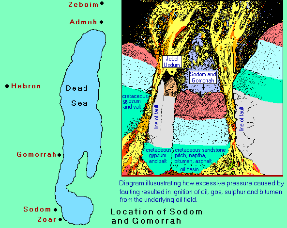
The Dead Sea is a part of this rift. So the topography of the real crossing-place is wholly unlike anything in the Gulf of Suez. It used to be said that Sodom and Gomorrah are beneath the Dead Sea, but Jonathan Gray and Ron Wyatt claim convincingly that they have found all five cities.
The whole area around the Jordan-Araba rift valley of the Dead Sea is oil-bearing. Geologists inform us that the southern Dead Sea is a burnt-out oil field. As the diagram indicates, an earthquake caused a section of earth's crust to slip along the fault. A drop of just one inch would wreck a large city. The tremendous pressure exerted by the dislodged mass forced the underlying oil and gas up along the fault lines into the atmosphere where they ignited to form a continuous liquid fire. According to Genesis 19:24, "the Lord rained upon Sodom and upon Gomorrah brimstone and fire out of heaven". Professor Kyle found "Pure sulfur in pieces as big as the end of my thumb. It is mixed with the rich soil of the mountains on the west side of the Sea and is now to be found scattered along the shore of the Sea to the east side..."
Genesis 19:27-28, "Abraham got up early in the morning to Hebron where he stood before the Lord: And he looked toward Sodom and Gomorrah, and all the environs of the Jordan Valley, and beheld, and, the smoke of the country went up as the smoke of a furnace".
From a map, we can see Abraham was thirty miles from Sodom as the crow flies. No doubt he climbed the highest vantage point, and he saw great black clouds of dense smoke from the burning oil.
Moses, writing 500 years after the destruction of the cities of the plain, tells us that the salt, the brimstone and the burning that took place in this area centuries before his time, had left very apparent evidence, and he was able to draw the attention of the people of his day to these tokens of judgment that could be observed by them whilst passing through that area.
Deuteronomy 29:23, "The whole land thereof is brimstone, and salt, and burning, that it is not sown, nor bears, nor any grass grows therein, like the overthrow of Sodom, and Gomorrah, Admah, and Zeboim, which the Lord overthrew in his anger, and in his wrath".
Writing after the death of Christ, Josephus said, "The country of Sodom . . . was of old a most happy land, both for the fruits it bore and the riches of its cities (from bitumen deposits) although it be now all burnt up.
It is related how for the impiety of its inhabitants (Jude 1:7), it was burnt by lightning; in consequence of which there are still the remainders of that divine fire; and the traces or shadows of the five cities are still to be seen, as well as the ashes. . ."
The ruins of these cities were extant in the days of Moses, Jesus and Josephus. And in 1991 Ron Wyatt discovered what he believed to be the cities of Sodom (behind Mount Sodom), Gomorrah, Zoar, Admah at the northern end of the Dead Sea, and Zeboim north of Jericho.
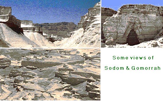
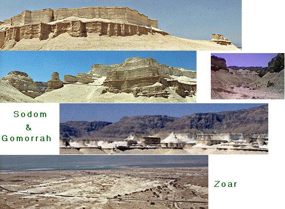
Within the perimeter of each site, everything has been turned to white ash in contrast with the brown stony desert.
Among the ashes at all five sites are countless pieces of brimstone, or sulfur, like bantam chicken eggs. I've actually held a piece in my hand.
There are no active or extinct volcanoes in the Dead Sea area. And nowhere else are balls of brimstone encased in burnt sulfur to be found. In cities such as Pompeii, which were destroyed by volcano, the people and artifacts which have been uncovered were turned to stone.
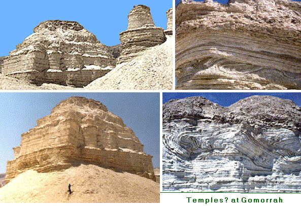
Here, although everything retains its original form, it has been turned to ash as II Peter 2:6 says. These points are submitted as an evidence that these are indeed the cities of the plain destroyed 3,900 years ago.As Sodom and Gomorrah may have looked before the destruction (below).
The largest city, thought to be Sodom, stands next to Mount Sodom. Close by stands Zoar, the smallest of the five. Lot wanted to flee to Zoar which he called "a little city". The second largest and best preserved of the five sites is believed to be Gomorrah, and it lies to the north of Sodom, between Masada and the Dead Sea.

After that tangent, let's take a look at the actual crossing-place at the Red Sea.
The Wadi Watir leads through the mountains, opening on the middle of a wide sandy beach on the Gulf of Aqaba. The beach at Nuweiba is large enough for Israel to "encamp by the sea" where the desert had "shut them in" (Exodus 14:2-3). The beach is 4.25 miles long by 2 miles wide. It appears clearly on satellite pictures, and is the only site that matches all points of the Bible account.
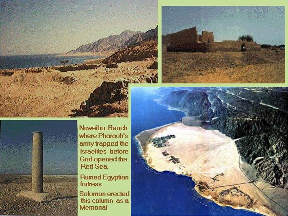
The only entrance to the beach at Nuweiba is by the Wadi Watir. On the northern end of the beach was an Egyptian fortress whose ruins still stand as evidence of Egyptian strategic interest. This would have prevented them from going north after they entered the beach. They were trapped "between Migdol and the sea". Migdol was perhaps a watchtower above the mountains from which the Egyptians observed shipping movements and other activities, relaying any intelligence from watch-tower to watch-tower by mirrors in the daytime and fires by night. Thus Pharaoh would have been constantly posted of Moses' progress.
Once Pharaoh's army had entered the gorge, Israel was "shut in" by the mountains. Pharaoh's army trapped Israel, but God had trapped Pharaoh's army. Exodus 14:3-4, "Pharaoh will say of the children of Israel, 'They're entangled in the land, the desert has shut them in'. And I will harden Pharaoh's heart, so that he follows after them; and I will get honour over him, and all his host; so the Egyptians may know that I am the Lord. And they did so".
Skeptics claim Israel didn't cross the Red Sea, but marshland near Succoth called the Sea of Reeds in the vicinity of the Suez Canal. I have a NASV Bible. That's what that map says. It might provide a plausible explanation as to how the Hebrews crossed but it doesn't explain how Pharaoh's chariots, his host and chosen captains were all drowned, or how the depths covered them so they sank to the bottom as a stone (Exodus 15:4-5). Let's see what God's Word says.
Exodus 15:19, "The horse of Pharaoh went in with his chariots and with his horsemen into the sea, and the Lord brought again the waters of the sea upon them; but the children of Israel went on dry land in the midst of the sea".
Isaiah 43:16-17, "Thus saith the Lord, who makes a way in the sea, and a path in the mighty waters; who brings forth the chariot and horse, the army and the power; they shall lie down together, they shall not rise: they are extinct, they are quenched as a wick".
Isaiah 51:10, "Are you not He Who dried the sea, the waters of the great deep; that made the depths of the sea a way for the ransomed to pass over?"
Isaiah 63:11-13, "Then his people remembered the days of Moses and his people, saying, 'Where is He that brought our fathers out of the sea with the shepherd of His flock? where is He that put His Holy Spirit among them? That led them by the right hand of Moses with His glorious arm, dividing the water before them, to make Himself an everlasting Name? That led them through the deep, as an horse in the wilderness, that they should not stumble"?
I've studied the bathymetric chart, and the Gulf of Aqaba is over one mile (1,800 metres) deep. The western (Sinai) shoreline drops underwater at an angle of 45 degrees. However, from Nuweiba beach, a massive sandbar almost a mile wide at its summit, slopes gently at six degrees until midway across the Gulf its 900 feet below the sea, and rises to the eastern (Midian) shore at the same kindly angle.
The distance from Nuweiba to Baal-zephon on the opposite coast is eleven miles. Nature has formed this land bridge at the narrowest section of the Gulf by accumulating sediments washed from the mountains on either side when the wadis are in flood.
Isaiah 43:16-17 calls the great land bridge, "a path in the mighty waters". Psalm 77:19-20, "Your wayis in the sea, and Your path in the great waters and Your footsteps are not known. You led Your people like a flock by the hand of Moses and Aaron". Isaiah 63:12, ". . dividing the water before them".
Moses and the Hebrew children were trapped. Exodus 14:19-22, "And the angel of God which went before the camp of Israel moved behind them; and the pillar of the cloud went from before their face, and stood behind them: between the camp of the Egyptians and the camp of Israel; and it was a cloud and darkness to them, but it gave light by night to these: so that the one came not near the other all the night. And Moses stretched out his hand over the sea; and the Lord caused the sea to go back by a strong east wind all that night, and made the sea dry land, and the waters were divided.
And the children of Israel went into the midst of the sea upon the dry ground: and the waters were a wall unto them on their right hand, and on their left".
I'll wager that wind was cold. Soldiers would have no desire for war that night. Exodus 15:8, "The waters were gathered together, the floods stood upright as a heap, and the depths werecongealed in the heart of the sea". The divided sea became walls of solid ice, 1,000 feet high. And as the wind abated, the Hebrews walked unhindered for eight miles across the land bridge above the sea floor to Midian on the farther shore. All the while the Pillar of Fire and Cloud protected them.
This principle by which God froze the walled-up sea is not unknown to the desert-dwellers. Villagers in Iran erect parallel stone walls. Towards night, as temperatures fall, they pour water in the channel between the walls. Wind passing through the narrow space causes it to freeze. And south of Flagstaff, Arizona, wind blowing through ice caves freezes seepage producing natural refrigeration.
Exodus 14:23-28, "The Egyptians pursued, and went in after them to the midst of the sea, all Pharaoh's horses, his chariots, and his horsemen. And in the morning watch (that's between 0300 and 0600 hours) the Lord looked unto the host of the Egyptians through the pillar of fire and of the cloud, and troubled the host of the Egyptians, clogging their chariot wheels, that they drove heavily and broke: so that the Egyptians said, 'Let us flee from the face of Israel; for the Lord fights for them against the Egyptians'.
And the Lord said unto Moses, 'Stretch out your hand over the sea, that the waters may come again upon the Egyptians, upon their chariots, and upon their horsemen'.
Moses stretched forth his hand over the sea. And as day dawned; the ice began to thaw, and the Egyptians ran into it; and the Lord drowned the Egyptians in the midst of the sea. The waters returned and covered the chariots, the horsemen and all the host of Pharaoh that pursued them; not so much as one of them remained".
It probably took until about one o'clock for the wind to divide and freeze the sea, five hours more for the Hebrews to cross with their animals and possessions, and by 0600, the first of Pharaoh's 600 chosen chariots would be nearing the eastern shore, followed by 251,000 foot soldiers -- all below the sea level.
The air was still. There was now no wind, and they must have been certain of apprehending their erstwhile slaves. Suddenly, like the roar of a volcano, the walls of ice split. In an instant a quarter of a million Egyptians were dead.
I've seen underwater slides and video film by Jonathan Gray, whose team found the site. They show the remains of Egyptian chariots, without wheels. Scripture explains how the thin rims sank into the mud formed by the melting ice, became clogged and broke from the axles. The four, six and eight-spoked chariot wheels were identified by the Department of Antiquities in Cairo as belonging to the 18th Dynasty. Apparently, monuments can actually be dated by the number of spokes in a chariot wheel carved in a frieze. And only during the 18th Dynasty were four, six, and eight- spoked wheels used (see Observations on the Evolving Chariot Wheel in the 18th Dynasty, James K. Hoffmeier. JARCE, #13, 1976).
None of these artifacts had been discovered previously because the archaeologists had been searching for the Red Sea crossing in the wrong location. Recently, Ron Wyatt found a Phoenician column on the southern end of Nuweiba beach. Its inscriptions were defaced or eroded. Later an identical column was discovered at Baal-zephon on the opposite shore. Its inscriptions, which are intact, say it was erected by King Solomon in honor of Jehovah, and dedicated to the miraculous crossing of the Red Sea by Moses and destruction of the Egyptian host.
We marvel at how the Lord has preserved these sites intact through the course of history. If their true locations had been known all along, there would be no evidence remaining today. We live in the days when even Bible cartographers and ministers don't believe the Red Sea crossing ever occurred.
Passing through the desert of Sin, Israel camped in Rephidim. See Exodus 17:3-6, "The people thirsted for water and murmured against Moses, saying, 'Did you bring us out of Egypt to kill us and our children and our cattle with thirst'?
And Moses cried to the Lord, 'What shall I do to this people? they are almost ready to stone me'.
And the Lord said to Moses, 'Go before them with some elders, and take your rod in your hand, with which you smote the Nile, and go. Behold, I will stand before you there on the rock in Horeb; and you shall strike the rock, and water shall come water out of it, that the people may drink'. And Moses did so in the sight of the elders of Israel" (I Corinthians 10:4).
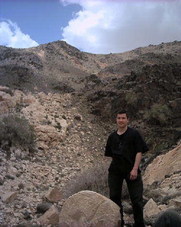
This rock is a prominent landmark that stands sixty feet above the western foothills of Mount Sinai. (The Sinai encampment was on the east). The rock has a split wide enough for a man to pass through. Erosion shows abundant water once flowed forth by channels to the plain below. Nearby to the south west, is the oasis and town of El Bad, where Moses' father-in-Law, Jethro, is said to have lived.
Separated by desert from the mountain range bordering the Red Sea, Jebel El Lawz is known to locals as "the mountain of Moses". At 8,000 feet, it is the tallest mountain in the region and forms a natural ampitheatre enclosing an area of 5,000 acres -- sufficient to accommodate two to three million people, with their flocks and herds. The name "Horeb" survives in the Wadi Hurab, which extends from Mount Horeb (Jebel El Lawz) to the foothills.

The entire summit of the mountain is blackened as if burned by intense heat. Exodus 19:18, "Mount Sinai was altogether covered in smoke, for the Lord descended upon it in fire: its smoke ascended like that of a furnace, and the whole mount quaked greatly".
Moving to the eastern side where Israel camped are two peaks. Just below one peak is a cave. I Kings 19:8, "Elijah . . . went . . . unto Horeb, the mountain of God.
And he came hither unto a cave, and lodged there". Could this be Elijah's cave? On the peak above this cave are two huge boulders with a solitary tree growing between them. Mohammedknew these parts, and visited this mountain at least once in about AD 631 to sign peace treaties with the Christian chief of Aqaba and Jewish tribes in the oases of Maqna within walking distance of the Mount. There is reference to such a tree in the Koran. In Chapter Sura (paragraph 20), Allah is said to state, "We produced for you . . . a tree issuing from the Mount of Sinai that bears oil and seasoning".
Between these two peaks is a cleft in the rock. Perhaps it's the place where Moses saw the "back parts" of God (Exodus 33:22-23).
Here is the course of "the brook that came out of the mountain" into which Moses cast the gold dust ground from the golden calf (Deuteronomy 9:21). From the Koran it is apparent the locals were familiar with Sinai and this brook. "The Story" (paragraph 29-30), says "Moses said . . . 'I observe a fire . . .' When he came to it, a voice came from the right bank of the watercourse, in the sacred hollow coming from the tree: 'Moses, I am God'." The "sacred hollow" describes the area at the foot of the blackened mountain I called an ampitheatre. And the"tree", that on the farthest peak to the right of the brook.
In paragraph 44 of the same book, the Koran states, "Thou wast not upon the western side when We decreed to Moses the Commandment nor wast thou of those witnessing".
This says that the local Arabian people being addressed weren't on the "western" or opposite side of the mountain when the Law was delivered to Moses, nor were they on the eastern side where "those witnessing" were located.
Exodus 19:12 tells how God instructed Moses to separate the people from the Mountain, that it may remain sanctified. "You shall set bounds round the mountain, saying, 'Take heed to yourselves, that you go not up into the mount, or touch the border of it: whosoever touches the mount shall be surely put to death".
The accompanying diagram shows the location of masonry wells about 18-foot in diameter roughly parallel to the lines which would have cordoned off the mountain. These are not readily apparent as only the tops can be seen above ground. They commence by the dry water course of "the brook that descended out of the mount", rest on the bedrock and follow the broken line on the map across to the south-western part of the mountain.
Exodus 24:4, "And Moses . . . built an altar under the hill, and twelve pillars, according to the twelve tribes of Israel". At the eastern foot of the mountain by the descent of the brook is such an altar of unhewn stones. And within the holy boundary is a semi-circle of twelve large white granite pillars.
Also found is the altar to the golden calf with twelve petroglyphs around it. The top of the rock is worn, perhaps by the golden calf when Moses "sacrificed" it upon its own altar, grinding it to dust before making Israel drink it (Exodus 32:20).
Exodus 33:7, "Moses took his tent and pitched it without the camp, afar off from the camp, and called it the tent of meeting. And it came about that every one who sought the Lord went out to the tent of meeting which was outside the camp".
At the foot of the mountain adjacent to Moses' altar lies prepared ground which may be the place where the animals were corralled.
These artifacts have been reported by Jonathan Gray and Ron Wyatt who have been working this area in recent years. To me, the import of these discoveries is not that they confirm Bible facts for the benefit of skeptics. They'll never believe and Jesus didn't die to redeem the doubter and unbeliever. Moses brought two million such people with him on the Exodus, and Jesus said all of those adult Israelites with the exception of Joshua and Caleb are removed from the Book of Life (John 6:49).
All of these discoveries show us what God did yesterday. We must learn what He's doing now, and see that part of His Word living through us. He is the same yesterday, today and forever.
It is clear that by comparing the Bible text which is supported by these discoveries with maps accepted by scholars since the days of Constantine, that we see we must go back to God's Word. Not man's maps, and prove all things, holding fast that which is good. Examine our selves, whether we be in the faith, or followers of Bible school curricula.
It is impossible to correlate the duration of certain legs of the exodus and the topography described by Moses with maps drawn by theologians based on the whims of the pagan emperor Constantine, and his mother, Helena, who identified a mountain in the Sinai Peninsula as Mount Sinai.
Von Haven, a member of the Danish Expedition of 1761-1767 wrote, "I have observed earlier that we could not possibly be at Mount Sinai. The monastery (of St. Catherine) was situated in a narrow valley, which was not even large enough for a medium-sized army to be able to camp in, let alone the 600,000 men that Moses had with him, who, together with their wives and children, must have come to over 3,000,000" (Arabia Felix: The Danish Expedition of 1761- 1767, by Thorkild Hansen. Harper & Ross, NY., 1964, page 181).
So long as the Bible was sealed with seven Seals, and Christ was a Mediator, God "winked at this ignorance". He's not winking today. We must empty from the cupboard of our minds, all man-made ideas, which are stumbling stones in the pathway to faith.
God sent us a prophet whose ministry restored the apostolic faith, finished the mystery of God, and is calling God's people OUT from human reasoning into the unity of the one and only understanding or faith of His Word, for the manifestation of the Sons of God and the great translation.
The Spiritual significance of this lesson is to receive what I and other men preach, then search the Scriptures whether it is so. You must make sure what you receive into your soul is God's mind, not some story put together by a preacher.
The world's largest-selling book is still the Bible. Billions and millions of Korans have been printed over the centuries. Billions of Bibles with false information on their maps. Millions of Christians, and hundreds of thousands of ministers and theologians have studied the Scripture we read today, thousands of archaeologists and explorers have trekked and sought in vain, not recognizing theerror in these maps by the truth of God's Word.
That's denominationalism and a second-hand religion. It's placing blind trust in the word of parents, teachers and preachers, not a personal faith in Jesus who is the Word. Its not relationship with Him as Husband. By this casual attitude to the Word men still hold Him to be some fraction of a trinity of Gods, and are baptized in three of His many Titles, not in the Name of those three Titles. There is no intimacy, no heart-desire to know Him, but a luke-warm Laodicean attitude of one who has gone through the outward form of being a wife. And the husband can take it or leave it.
This attitude will not get us to the Wedding Supper today. We live in the Age of perfection. We live in the day of Christ's parousia: the day of God's Judgment on all outside the fullness of His Word.
Exodus 32:25-28, "When Moses saw that the people were naked; (for Aaron had made them naked to their shame among their enemies): He stood in the gate of the camp, and said, 'Whoever is on the Lord's side, let him come to me'. And all the Levites gathered themselves together to him. And he said to them, 'Thus saith the Lord God of Israel, Every man put his sword by his side, and go in and out from gate to gate throughout the camp, and slay every man his brother, and every man his companion, and every man his neighbor'.
And the children of Levi did according to the word of Moses: and there fell of the people that day about three thousand men'."
We live in the end-time. Christ is again without the Camp, calling those who are His own to draw the Sword of the Word and separate from golden calf schemes. The Levites had no inheritance in this earth for the Lord was their portion. They type the Bride and lived by His Word. Like Abraham, they sought a City whose Builder and Maker is God.
Let us like Moses, commune with God without the camp, and like the Levites, separate from those who follow carnal reasoning against the revealed Will and Word of God. bb971126.htm
e-mail: ags@biblebelievers.org.au
Beautiful work. Thank you.
ReplyDeleteYou're welcome! :D I would like to share another work i've done which is filled with Biblical Treasures, beautifully illustrated for you :)
Deletebible7treasures.blogspot.com
May The Lord Jesus Christ Bless you! :D
Beautiful work. Thank you.
ReplyDeleteYou're very welcome! :D May The Lord Jesus Christ Bless you! :D
DeleteGreat work my brother. Thank you for putting everything conveniently on one page! Hope everyone who sees may believe and continue in their journey of faith, knowing that our God is the best and our scriptures are very accurate! Halleluyah! Blessings
ReplyDeleteOur God Is The Only God! :D Glory To The Lord Jesus Christ! ^____^ I'm glad you like this work. I also would like to share another work I've done, with you. It is filled with Biblical Treasures :D
Deletebible7treasures.blogspot.com
May The Lord Jesus Christ bless you! :)
I forgot to say, "You're very welcome!" :D May The Lord Jesus Christ Bless you!
ReplyDelete